The Value of Ground Weather Stations Over Other Data
An accurate and long-term understanding of weather patterns is key to agricultural and energy investments. Weather data is a critical enabler of shrewd agricultural and renewable energy investment. This article explores the importance of weather data and compares ground weather stations to weather satellites and radars. We will also go over Organic Yemen's offerings when it comes to weather monitoring products, services and solutions.
Importance of weather data for agriculture
Weather stations in the United States provide farmers with daily, accurate weather information
Weather data informs all about farmer’s operational decisions. For example, the precise date to plant, whether to make an application, anticipate harvest, schedule irrigation, and others. It helps in identifying locations for farms, predicting yields, and providing early warning for damaging conditions like flooding and insect attacks. It also offers a predictive basis for the operational efficiency of solar and wind power plants.
Effective use of weather and seasonal forecasts, as well as agrometeorological advisories, reduces climate risks for farming communities. And it provides them with well-adapted guidance on managing agro-climatic resources at local levels. Investors can also predict the success of their investments in agricultural production and renewable energy systems, such as solar and wind.
Getting weather data in Yemen
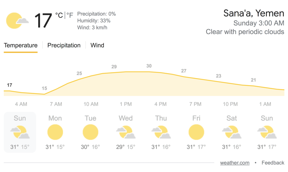
Yemen’s weather data from Google
For Yemen weather data, there are different options to choose from. The most common options are ground weather stations, weather satellites (polar-orbiting and geostationary), and weather radars. Each of these confers different benefits in terms of observational representativeness and measurement capabilities.
Nevertheless, ground weather stations, despite being the oldest and most classical of the lot, are still the handiest. They remain the most suitable choice for farmers and investors.
Why ground weather stations?
A ground weather station, farmer’s best friend
1. Ground weather stations are more accurate
Weather satellites, much like weather radars, despite enabling high spatial coverage, provide generalized and imprecise data. For example, a weather satellite will give the same measurements for an area covering 4-10 sq km, depending on the satellite model, whereas actual measurements can vary largely within this area. Conversely, ground weather stations enable users to reach direct physical parameters, such as temperature, wind, pressure, and precipitation.
Weather forecasting relies on huge amounts of observational data. However, weather satellites cannot measure key elements such as wind and rainfall as accurately as ground weather stations. Indeed, the latter integrates lightning sensors for tracking dangerous storms likely to bring severe weather and provide advance early warnings.
2. Better for agricultural purposes
Satellites need ground stations to confirm and calibrate their estimates and weather forecasts. Data from satellite and radar is therefore of little practical importance for Yemeni agriculture whose prospects are increasingly dependent on farm-specific data sets. Flood early warning systems also depend on exact rather than generalized data. Similarly, investment studies for agriculture and renewable energy depend on accurate information. Ground weather stations enable in-situ measurements. Whereas these are typically representative of small areas around the measurement site, their data is practically better for agriculture.
3. Longer time series, better analysis
The time series of both weather satellites and weather radar start from about the end of the 1990s to the present. This provides a narrow range, compared to ground weather stations, some of which measure from since the 1850s. Most, however, measure from the 1950s, comparatively availing long time series that can be very useful in Yemen climate change analysis.

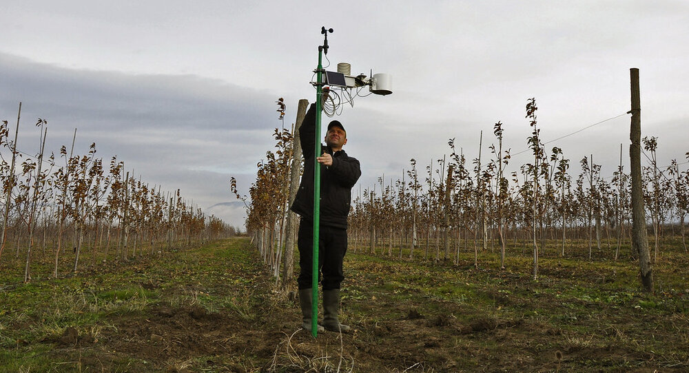
One example for a ground weather station
4. Ground weather stations are affordable
Weather satellites are also expensive to launch and operate. This suits national governments and third-party commercial operators rather than individual farmers. If anything, weather radar specifically does not exist in many parts of Yemen and is ineffective in mountain areas. This limits their practical use in the observation and measurement of Yemen weather data.
5. Direct measurements, no need to translate
Unlike ground weather stations, which enable direct measurement of the essential climate variables (ECV’s), with weather satellites and weather radars, you have to go the extra mile of translating their signals into the desired climate variables. This not only introduces additional uncertainties but also requires ground observations to make the translation.
6. Ground weather stations are stable
Ground weather stations are also more stable, unlike weather satellites and weather radars that are prone to systematic disturbances in the signal due to the atmosphere.
So generally, considering observational representativeness and measurement capabilities, ground weather stations are practically better for Yemen weather analysis.
What happens with lack of weather data?
How weather stations are helping farmers in India deal with climate change
Previously, having an accurate weather prediction for an agriculture farm was a challenge for Yemen farmers. Consequently, Yemen’s Investment in agriculture and energy resources was risky. This made farmers perpetual victims of destructive storms, floods, weather extremes, and winds, leading to agricultural losses. Yemen’s agriculture investment also suffered, affecting the country’s agricultural development.
What’s more, weather predictions of the country’s meteorological department are often general, making them undependable for making farm-specific decisions.
Fortunately, Organic Yemen’s weathering monitoring and measurement products and services are changing that narrative.
Organic Yemen’s weather monitoring products and services
Take better farming decisions with Campbell Scientific technologies from Organic Yemen
Organic Yemen (OY) consequently prioritizes environmental monitoring. It develops, installs, and maintains professional and field-centric weather stations for taking weather data locally in Yemen. We have the workforce and the expertise to install, program, and maintain Lastem and Campbell Scientific weather stations. We also provide data visualization and flood early warning software and training. Additionally, the company offers software and aids in choosing the most appropriate telemetry arrangement for your ground weather system.
Our idea is to enable you to make informed decisions regarding the weather affecting your operations. The weather stations suit all major areas of need, including areas of agriculture, industry, recreation, and renewable energy generation.
Organic Yemen provides a variety of weather stations, according to the number of parameters you want to measure, work precision, and the range. Examples of parameters that you can measure using weather stations from OY are rainfall, wind velocity and direction, solar radiation, and relative humidity, among others. You can equip our weather stations with a variety of models and sensors, depending on the specific needs of your farm.
With our science-based methods, we use precise data in investment reports for clients. Consequently, investors can be confident in OY’s estimated returns because we ground our projections on reliable data.